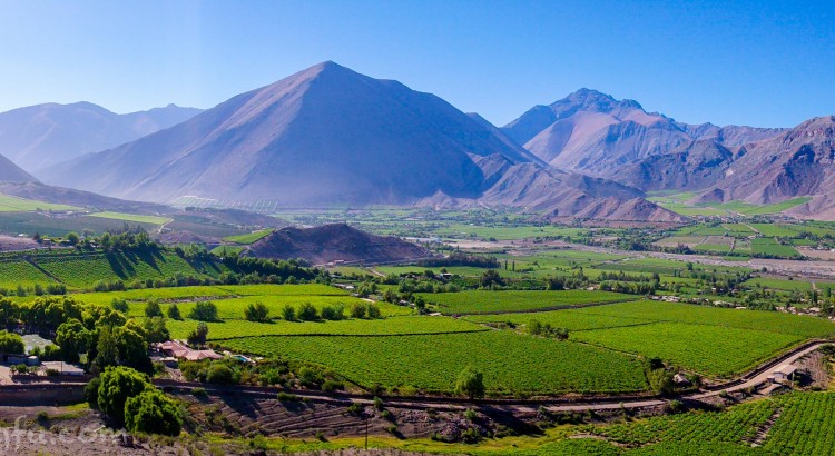
The Atacama Desert is pretty freaking big. 41,000 square miles big. It took us several long days of driving to make our way through it. Two other relevant bits of data: It’s also called the land of 10,000 mines and it is the driest non-polar desert in the world – the former leading to a tour of the largest copper mine in Chile and the latter partly explaining why so many of the world’s most important observatories are located here. It also provides plenty of opportunity for middle-of-freaking-nowhere-camping, which even after nearly a year on the road never gets old… (more…)
South America
South America
Shake, Rattle, and Roll – Adventure Driving in Bolivia
Remember that time we drove through a crazy remote border from Ecuador into Peru and thought it was pretty wild… well… ummm… meet Bolivia. Hundreds and hundreds of miles of horrible, corrugated, dirt tracks at ridiculously high elevations with no services, gas, or help in any direction for days and days… sounds like the perfect adventure for the Craggin’ Wagon! What could go wrong?
Chile
This page will include everything north of Patagonia in Chile. For the Patagonian region, click here.
Border: Hijo Canyon, Bolivia – San Pedro, Chile
Don’t forget to stop at the remote Aduanas office inside the Park at the Boric acid plant to hand over your vehicle papers!!!
Bolivia Side – Hijo Canyon
- Go to Aduana office, turn in permit (S22 26.454 W67 48.357)
- Drive to immigration (S22 52.860 W67 47.901)
- Stamp out. New requirement at this border is a Bs fee of 15-20 pp for maintenance of the border.
Chile Side – Drive 30 minutes to San Pedro
- Go to immigration, fill out tourist card. They will enter info into computer and hand passports and copy of tourist card.
- Go to aduana’s. Give registration and driver’s passport (they will not need copies). They will give you a vehicle permit.
- Across the street is the declaration building. Need to fill out forms declaring stuff. If you have any eggs, milk, cheese, vegetables, you need to say yes on form. They will search your car and if you said no, it is a $200 US fee if you have anything that you did not declare.
We were never asked to present proof of Chilean insurance at either border or during our time in the country, but it is obligatory. You can easily and cheaply purchase it online here: http://www.magallanes.cl/venta/index.aspx?key=k66cl3
Our Route
Chile Tips
- Be careful entering Chile. They will hijack you for your food at every border! Sometimes they take your cheese and vegetables, other times they’ll take your meat and dairy. The best thing to do if you’re like us and carry a lot of food with you is to stop before the border and hide it. Do this at your own discretion though – if you were to get caught they claim there is a $200 fine. We hid our food in a backpack way under the bed and left a few things in the fridge on purpose, claimed them on the form, and let them confiscate it. Worked fine.
- Copec truck stops/gas stations are excellent places to camp free if you’re on a major highway. They have bathrooms, showers, security, free wifi, and sinks for water and dishes.
- We were randomly pulled over and had our van searched by drug dogs, this would be a bad country to drive around in with anything.
- The limit for drinking and driving is so low in Chile that you essentially cannot even have one drink.
- There are a lot of campgrounds in Chile’s cities, but they’re expensive. We found stealth camping or camping at Copec stations saved us a great deal of money.
- Gas is also really expensive.
![]()
Bolivia
Border: Yungay, Peru – Copacabana, Bolivia
Yungay is the easier, more relaxed, more scenic border crossing from Peru into Bolivia. Both towns are on Lake Titicaca and shouldn’t be missed!
Peru Side
- Drive up to the chain across the road and park.
- Go to the police office just to the right of immigration. An official will stamp your card.
- Go to immigration building for stamp and they will keep the tourist card.
- Go to white aduana building across the street and hand over permit.
Bolivia Side
- Park before gate after arch.
- Fill out 2 forms of paper work at immigration. Need a passport and a copy, completed tourist card, and completed visa form, and $135 (for Americans). They scanned our passports and we did not need passport photos.
- Official will place visa sticker and stamp.
- Aduana’s (left of immigration) needs original and copy of: passport, registration/title to issue a permit.
- When leaving Copacabana a police officer will stop you and write information in a ledger, stamp permit, and charge Bs 20 for a piaje.
Our Route
Bolivia Tips
- Gassing up is tricky if you’re not from Bolivia. The international price is about triple what locals pay. Tell the attendant you don’t need a receipt and negotiate for a price between 5 – 7 Bolivianos per liter. We gassed up at 5 once, 6 twice, and 7 twice. Like anything in Latin America, the better your Spanish is and the more you argue the better you’ll do. Tell them that you paid 5 here yesterday and that your friends did as well. Also, hit the smaller stations on the outskirts when possible – they’re much more likely to sell to you if there’s fewer attendants, no bosses around, and fewer other patrons.
- The roads are rough on vehicles. Take your time on the wash board to save your suspension and not rattle your rig apart.
- Bolivia is in the process of constructing a nice, modern paved highway between Oruro and Uyuni. It is not complete and the road through is currently littered with detours and construction. If you’re not heading to Potosi or Sucre it’s doable. Careful if it rains, the entire thing becomes a mud slog.
- Don’t hand over original documents to the cops if you can avoid it. Use copies, especially of your license – the first cop we gave my license to wanted 200B to give it back. We eventually got it back and told him he could have 20B or nothing and were on our way. More arguing and demanding an official ticket would have eventually prevailed we think, but for less than 3 dollars US we preferred to just be on our way.
- Bring lots of sunscreen!
- Enjoy your time at the Oberland Hotel if you camp there, it’s the last good wifi for the country and the llama steaks in the restaraunt are excellent!
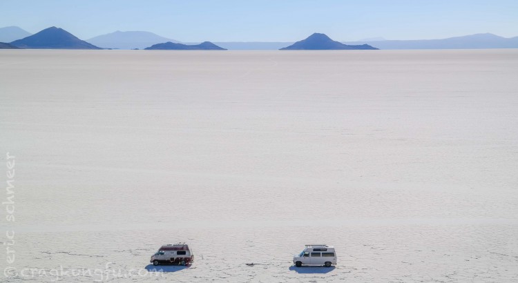
Salar Tips and GPS
- The main entrance to Salar (north of Uyuni about 12-16k) had several deep sections of brine and water. We had to pick and choose which spots to drive through versus around. We pretty much skirted the main water by driving around the whole mess on the right. If you’re unsure, wait for a land cruiser or two to come by with tourists and watch them. Great way to judge where to go and not to go. After that, it’s easy and perfect.
- The touristy Isla Incahuasi might be worth driving by or stopping at for a beer, but if you’re camping on the Salar and have your own rig you’ll want to head to the awesome Isla Pescado.
- We paid 50 Bolivianos at the very last building on the Southwest corner of town (near the gas station) for a car wash and fumigation (light coating of used motor oil on the undercarriage). Don’t skip this step when you’re done with the Salar. Salt is no bueno for your rig.
- The gas station on the Eastern side of town gave us the best price (6B) despite it being the busiest and the boss hanging around.
Salar GPS Waypoints (gpx file download at bottom of page)
- Eastern Entrance to Salar, -20.3162166670, -66.9808833330
- Isla Incahausi, -20.2411666670, -67.6275833330
- Isla Pescado – Free Campsite, -20.1390950000, -67.8105260000
- Salt Hotel, -20.3304666670, -67.0467000000
Southwest Circuit Tips and GPS
- We did this in our old van without 4X4.
- San Cristobal did have gas, however, they had no electricity to pump it with. Bring all you need. They sell 30 liter plastic gas jugs in Uyuni for 50 Bolivianos if you need to bring a bit more than usual with you. That said, it wasn’t as long of a drive as I had read in other blogs. We made it to the thermal springs easily before dumping in our cans and jugs (and we get pretty bad fuel economy). We arrived in San Pedro with well over half a tank left.
- You can buy water, candy bars, and beer at the thermal springs in a pinch.
- We did the easier of the tracks through the circuit. It involves hanging a left at Villa Alota with an immediate, fairly deep water crossing but easily manageable with a little speed.
- After that, there is a right hand turn that is the shorter way to the park entrance before Laguna Colorado.
- The roads were never bad in a four wheeling sense, but after San Cristobal there was almost constant, bad washboard and some spots with sand. Also, you’ll be driving to elevations upward of 16,500 feet where you’ll definitely lack normal engine power.
- DO NOT FORGET TO STOP AT ADUANAS 80KM PRIOR TO BORDER. You have to hand in your import papers for your vehicle there.
SW Circuit GPS Waypoints (gpx file download at bottom of page)
- San Christobal Fuel, -21.1570000000, -67.1683333330
- Villa Alota, -21.4039833330, -67.5978666670, Turn S to Villa Mar and at Villa Mar turn SW for the easier way into the park
- Turn for Park Entrance, -21.7707158697, -67.4635720253
- National Park Entrance Station (North), -22.0573499457, -67.6033544540
- Canyon Free Campsite, -22.2929380000, -67.7815280000
- Turn for Customs, -22.4248000000, -67.7737666670
- BOLIVIA CUSTOMS!!!, -22.4409000000, -67.8059500000
- Sol de Manana Geyser, -22.4354333330, -67.7571833330
- Hot Spring – Free Camp, -22.5355833330, -67.6494500000
- Dali’s Rocks, -22.6235780000, -67.6710410000
- Laguna Verde, -22.7866666670, -67.8202166670
- National Park Entrance Station (South), -22.8312666670, -67.7789166670
- Border Crossing – Bolivian Immigration, -22.8793380000, -67.7966880000
- Back on the Asphalt, -22.9206371487, -67.8071737289
- Chile Immigration/Aduana, -22.9110333330, -68.1937666670
Salar and Southwest Circuit GPX File Download
Click to download – Salar and SW Circuit Waypoints
![]()
Bolivia
La Paz
Aranjuez
Minutes away from La Paz and in the valley below Oberland (the popular overlander’s hangout) is Valle de Aranjuez. It is composed of about a dozen sectors spread out on both sides of the river. No need for gear, it’s only sport here including the cracks. The rock is… interesting. Lot’s of mediocre sandstone mixed with pretty smooth conglomerate. That said, there’s enough well equipped, thought provoking routes on good rock to keep you busy while you’re in the area. Also nice is the parking situation. There is a park stretching through the base of the valley that is quite safe for leaving a vehicle (or stealth camping). The approaches are short and the fins tend to have routes on each side which makes it easy to chase or dodge the sun.
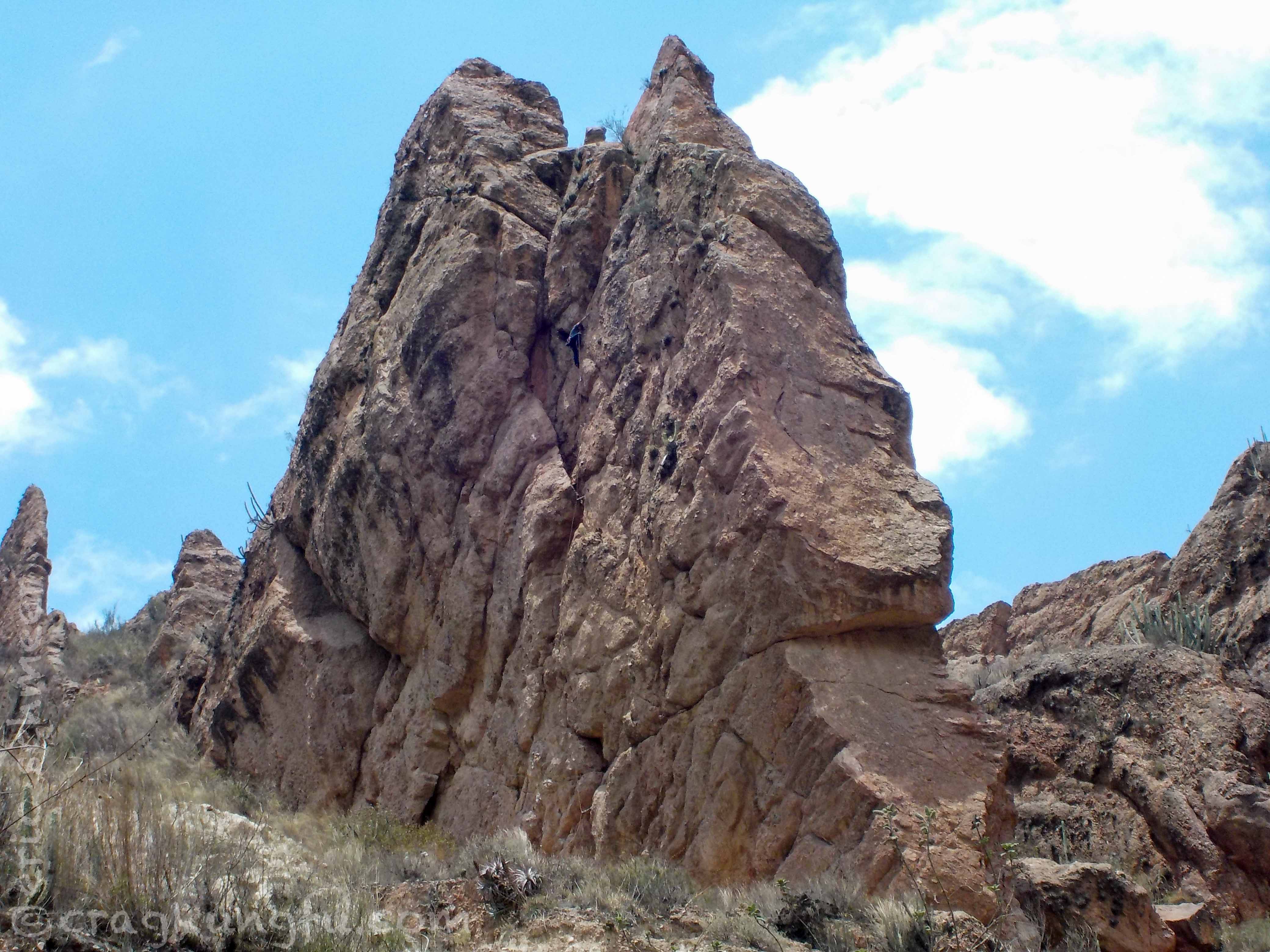

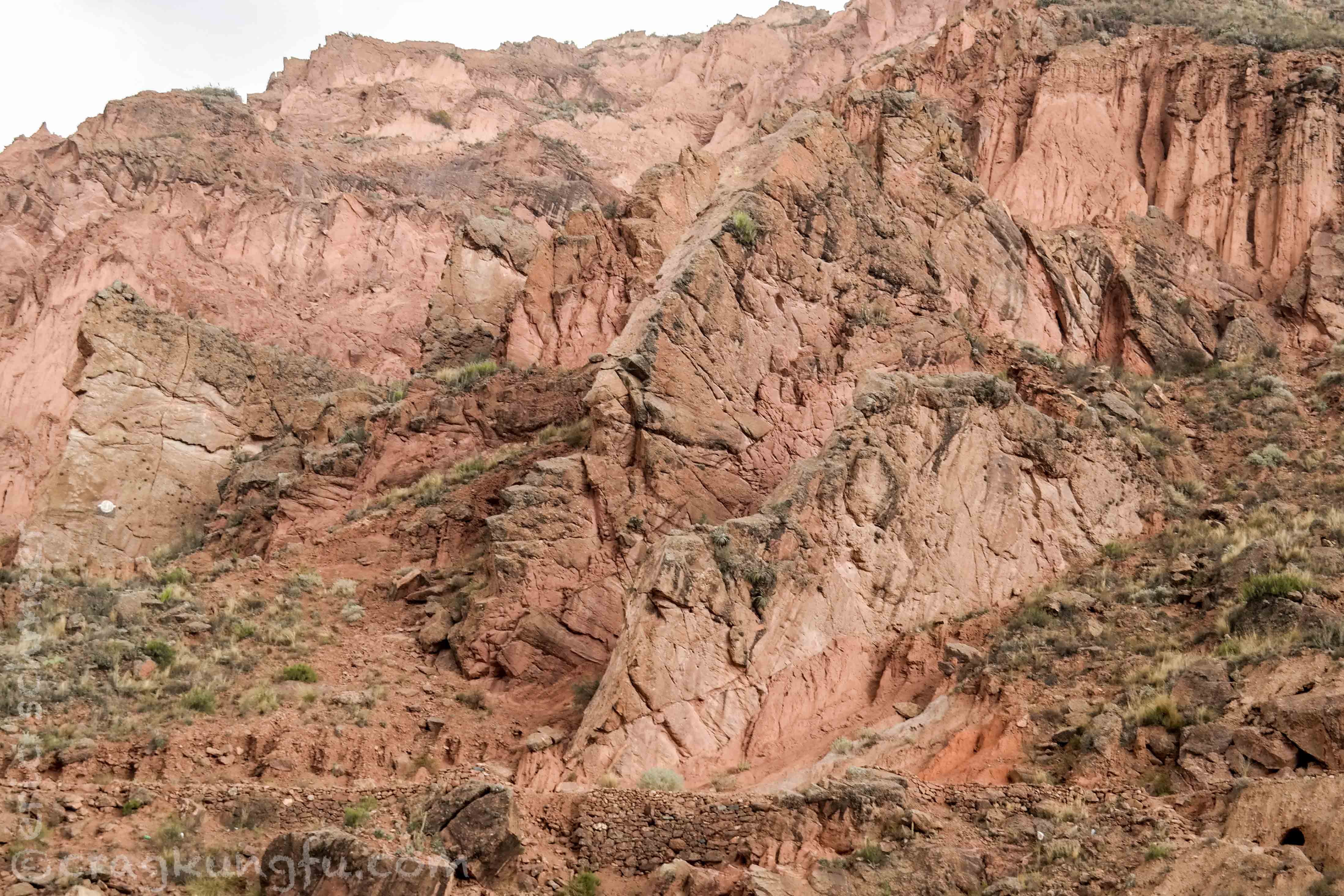
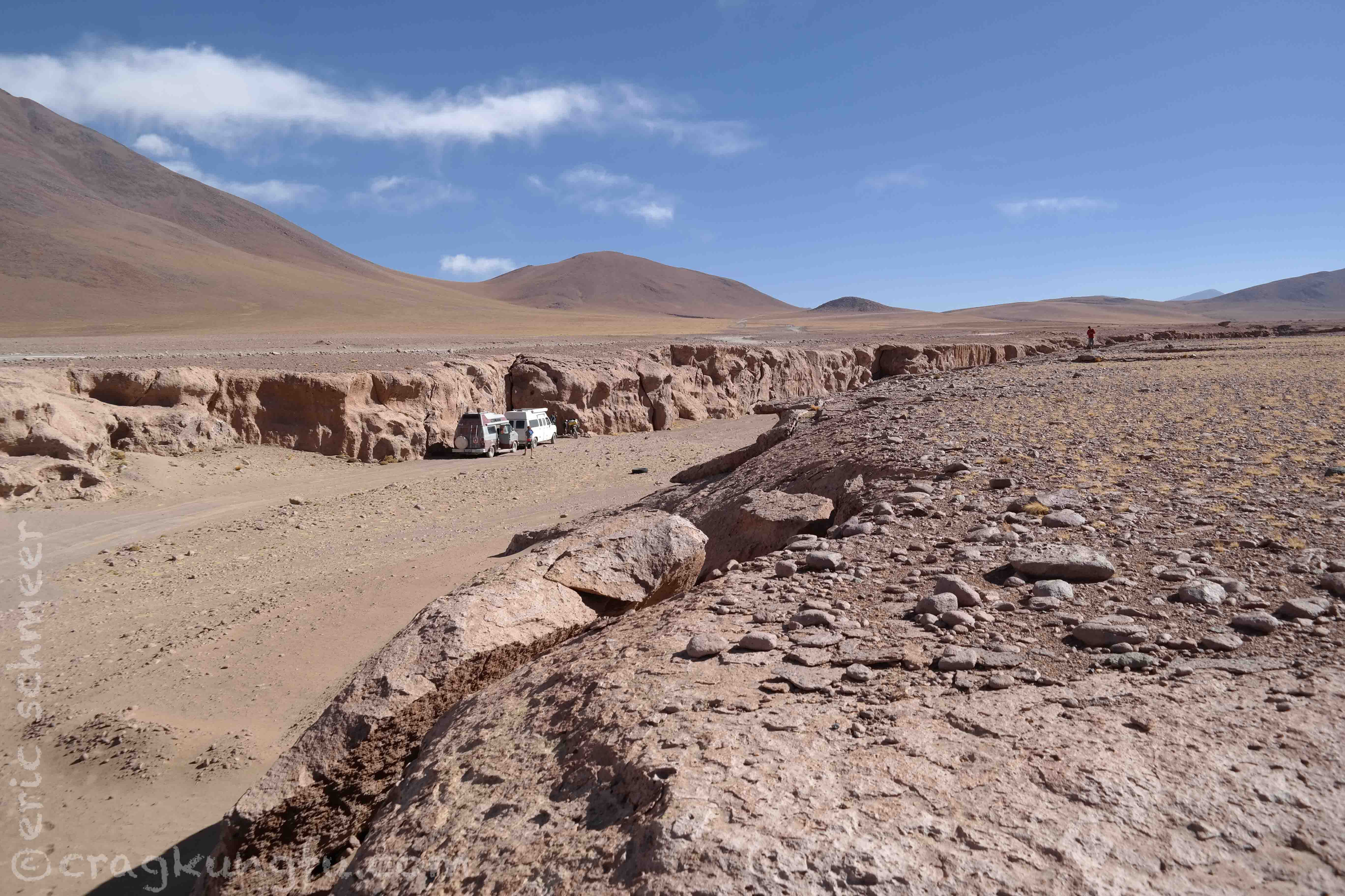
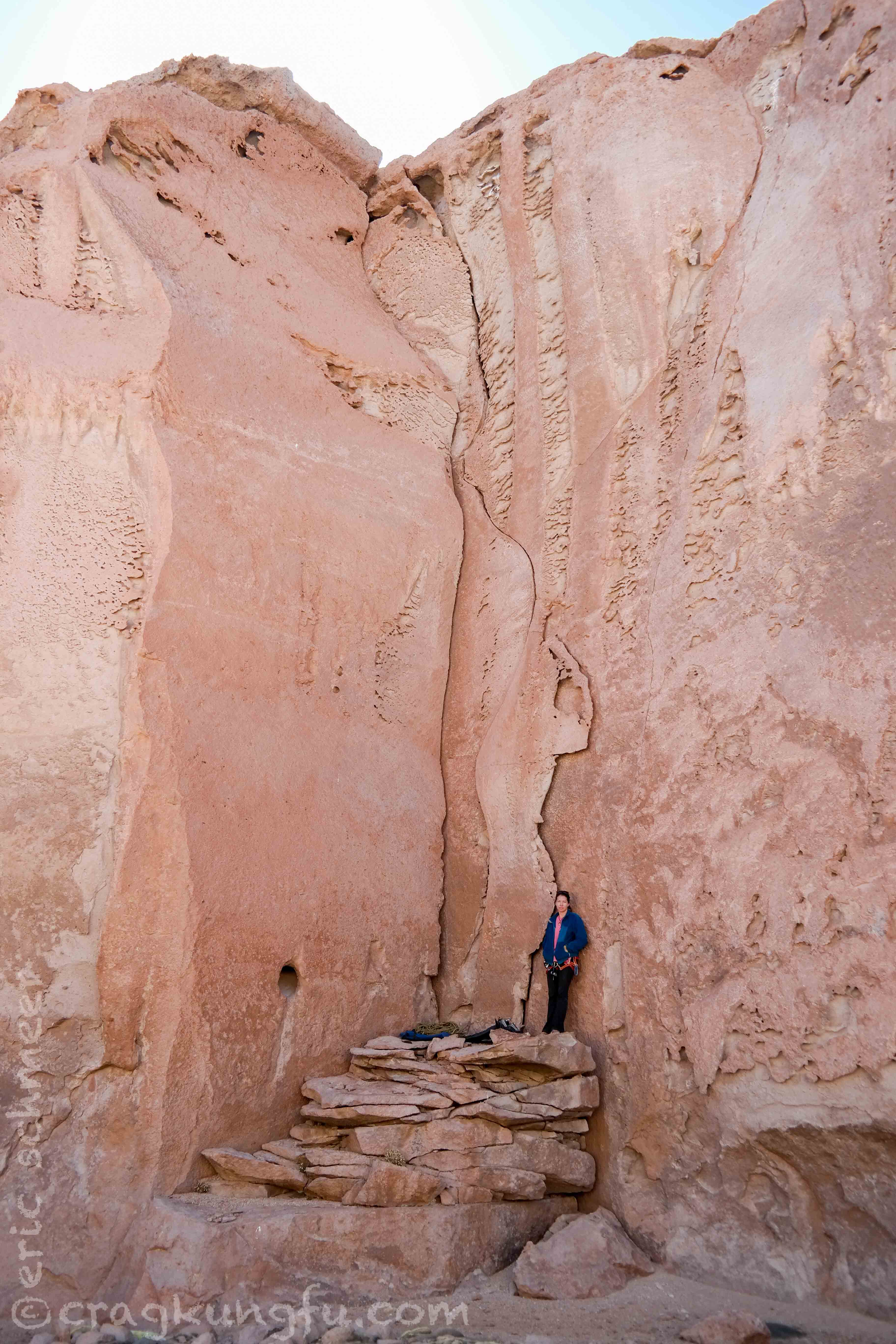
South of Laguna Colorado – Reserva Nacional de Fauna Andina Eduardo Avaroa
(-22.2929380000, -67.7815280000)
This is a good place to camp just South of Laguna Colorado. When we pulled into the canyon to camp we were amazed at the quality of the rock. There are endless lines to be done. Not the tallest, but high quality and SPLITTER! The most limiting factor that prevented us from doing more new routes was only having doubles with us. Having three, four, or more in whatever size you’d like to climb would go a long ways. The rock is very good volcanic stone with some features to use outside of the cracks as well. Also, if you boulder, bring your pad – the bouldering potential here is probably better than the climbing, which is also excellent. You can do FAs for as long as your supplies last at 14,000+ feet!!!

![]()